Depth
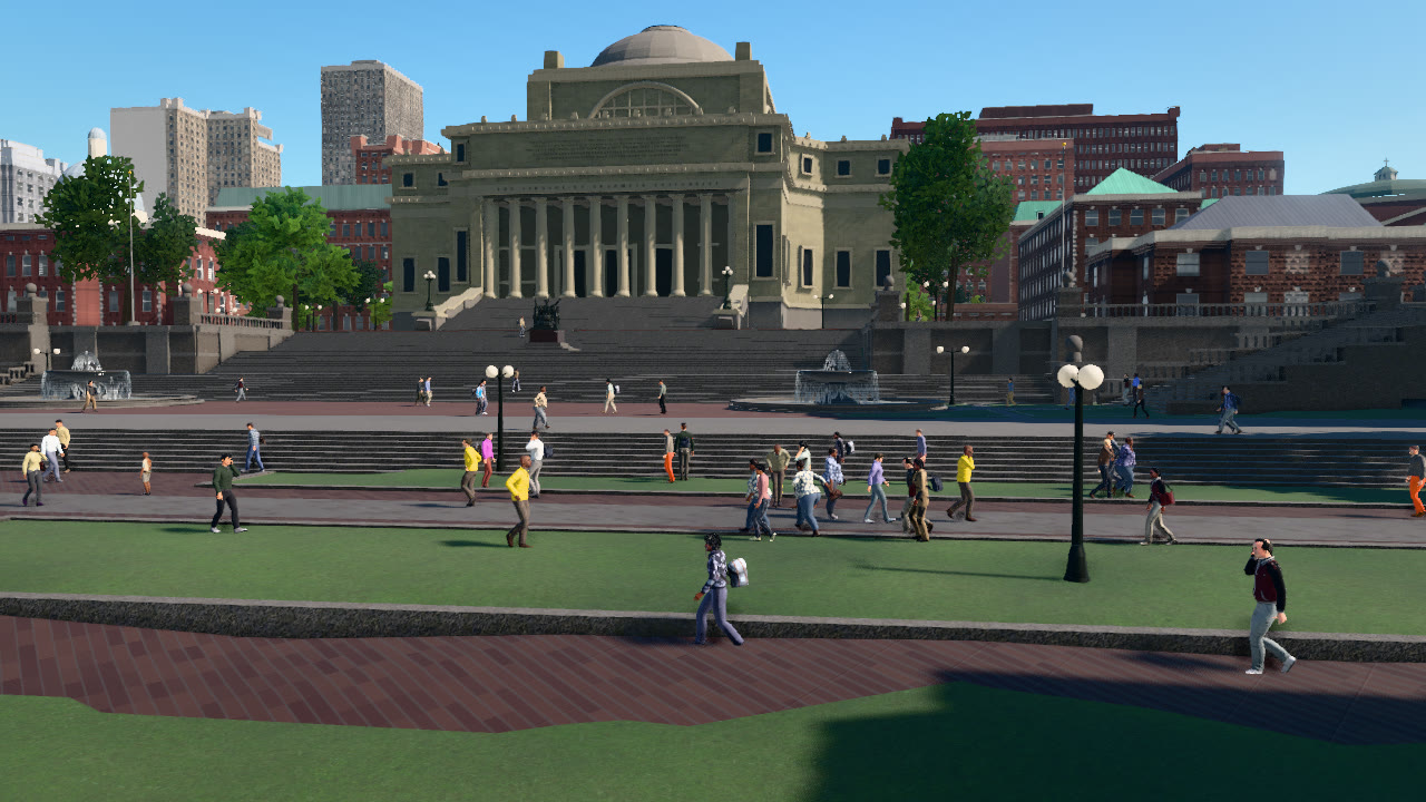
This tutorial places an RGB camera and a depth camera at one pose on Columbia's College Walk, facing Low Library. It saves the metric depth exactly and as a 16-bit PNG, writes a colour-mapped preview, and back-projects the depth into a coloured point cloud in the world frame.
Metric depth
depth.save_to_disk(os.path.join(a.out, "depth.npy"))     # float32 metres along the view axis
depth.save_to_disk(os.path.join(a.out, "depth.png"))     # uint16 millimetres; 65.535 m and beyond saturate
d = depth.to_numpy()
sky = d >= depth.depth_max                               # no geometry along the ray
A DepthImage holds one float32 per pixel: the distance in metres from the camera plane along the view axis (the
camera-frame x coordinate, often called z-depth), not the distance along the ray. Pixels where the ray meets no
geometry, the sky, hold depth.depth_max. save_to_disk chooses the format by extension: .npy and .pfm keep the
floats exactly, and .png writes 16-bit millimetres, which covers 0 to 65.535 m and saturates beyond. Keep the .npy
(or .pfm) file when the far field matters.
A colour-mapped preview
near, far = 2.0, depth.depth_max
x = (np.log(np.clip(d, near, far)) - math.log(near)) / (math.log(far) - math.log(near))
vis = turbo(1.0 - 0.9 * x)                               # near is red, far is blue
vis[sky] = (18, 22, 30)
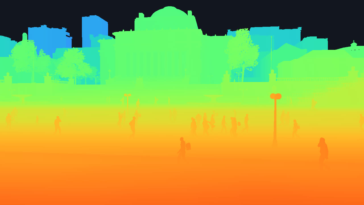
Depth in a street scene spans several orders of magnitude, so the preview maps the logarithm of the depth, from 2 m
to depth_max, to the Turbo colour map and paints the sky dark.
Back-projection
f = depth.width / (2.0 * math.tan(math.radians(depth.fov) / 2.0))          # focal length in pixels
# camera frame: x forward (the view axis), y left, z up; image right is -y and image down is -z
x = d[keep]
y = -(u[keep] + 0.5 - depth.width / 2.0) * x / f
z = -(v[keep] + 0.5 - depth.height / 2.0) * x / f
R = np.array(depth.transform.rotation.matrix())                             # body -> world
The cameras are ideal pinholes: the principal point is the image centre and the focal length follows from the
horizontal field of view, as valdrada.util.camera_intrinsics(width, height, fov) returns it. A pixel's depth and its
offset from the principal point give the point in the camera frame, and the sensor's world pose, which every event
carries in transform, takes it to the world frame. The script writes every second pixel's point with its RGB colour
to points.ply, a binary PLY file that point-cloud viewers open, and repeats the computation for the centre pixel with
Transform.transform_point.
The script prints:
depth: 5th / 50th / 95th percentile 9.8 / 31.5 / 218.2 m; sky 14.3 % of pixels; 46.0 % at or beyond the 16-bit PNG's 65.535 m
197190 points -> points.ply
image centre: 63.19 m along the view axis, world Location(x=771.161, y=2728.335, z=4.819)
The complete script
"""Depth: an RGB and a depth camera at one pose on Columbia's College Walk. Saves metric depth as float32 (.npy) and as
a 16-bit PNG in millimetres, writes a colour-mapped preview, and back-projects the depth into a coloured point cloud
(.ply) in the world frame. Needs numpy.

    python depth.py [--host 127.0.0.1] [--port 2000] [--out _out/depth]
"""
import argparse
import math
import os
import sys

import numpy as np

sys.path.insert(0, os.path.join(os.path.dirname(os.path.abspath(__file__)), "..", ".."))   # run from a source checkout
import valdrada  # noqa: E402
from valdrada import Location, Rotation, Transform  # noqa: E402
from valdrada.png import write_png  # noqa: E402

COLLEGE_WALK = (40.80712, -73.96232)       # Columbia University, south of Low Library


def turbo(x):
    """Turbo colour map for x in [0, 1] -> uint8 RGB. Polynomial fit of Turbo by Anton Mikhailov (Google, 2019),
    Apache-2.0."""
    x = np.clip(x, 0.0, 1.0)
    r = 0.13572138 + x * (4.61539260 + x * (-42.66032258 + x * (132.13108234 + x * (-152.94239396 + x * 59.28637943))))
    g = 0.09140261 + x * (2.19418839 + x * (4.84296658 + x * (-14.18503333 + x * (4.27729857 + x * 2.82956604))))
    b = 0.10667330 + x * (12.64194608 + x * (-60.58204836 + x * (110.36276771 + x * (-89.90310912 + x * 27.34824973))))
    return (np.clip(np.stack([r, g, b], -1), 0, 1) * 255 + 0.5).astype(np.uint8)


def back_project(depth, step=1):
    """World points (N, 3) and their pixel indices for every step-th pixel that is not sky."""
    d = depth.to_numpy()[::step, ::step]
    v, u = np.mgrid[0:depth.height:step, 0:depth.width:step]
    f = depth.width / (2.0 * math.tan(math.radians(depth.fov) / 2.0))          # focal length in pixels
    keep = d < depth.depth_max
    # camera frame: x forward (the view axis), y left, z up; image right is -y and image down is -z
    x = d[keep]
    y = -(u[keep] + 0.5 - depth.width / 2.0) * x / f
    z = -(v[keep] + 0.5 - depth.height / 2.0) * x / f
    R = np.array(depth.transform.rotation.matrix())                             # body -> world
    t = np.array([depth.transform.location.x, depth.transform.location.y, depth.transform.location.z])
    return np.stack([x, y, z], -1) @ R.T + t, (v[keep], u[keep])


def write_ply(path, xyz, rgb):
    v = np.empty(len(xyz), dtype=[("x", "<f4"), ("y", "<f4"), ("z", "<f4"), ("r", "u1"), ("g", "u1"), ("b", "u1")])
    v["x"], v["y"], v["z"] = xyz.T
    v["r"], v["g"], v["b"] = rgb.T
    with open(path, "wb") as f:
        f.write(("ply\nformat binary_little_endian 1.0\nelement vertex %d\nproperty float x\nproperty float y\n"
                 "property float z\nproperty uchar red\nproperty uchar green\nproperty uchar blue\nend_header\n" % len(v)).encode())
        v.tofile(f)


def main():
    ap = argparse.ArgumentParser(description=__doc__, formatter_class=argparse.RawDescriptionHelpFormatter)
    ap.add_argument("--host", default="127.0.0.1")
    ap.add_argument("--port", type=int, default=2000)
    ap.add_argument("--out", default="_out/depth")
    a = ap.parse_args()
    os.makedirs(a.out, exist_ok=True)

    client = valdrada.Client(a.host, a.port)
    client.set_timeout(120.0)
    world = client.get_world()
    original = world.get_settings()
    world.apply_settings(valdrada.WorldSettings(synchronous_mode=True, fixed_delta_seconds=0.05))
    m = world.get_map()
    here = m.geolocation_to_location(*COLLEGE_WALK)
    world.get_spectator().set_transform(Transform(here + Location(0, 0, 20)))
    world.wait_until_loaded()
    ground = m.get_surface(here)["height"]                  # the lawn's height in the world frame

    pose = Transform(Location(here.x, here.y, ground + 4.0), Rotation(pitch=-2, yaw=69))
    lib = world.get_blueprint_library()
    latest, cameras = {}, []
    for kind in ("rgb", "depth"):
        bp = lib.find("sensor.camera." + kind)
        bp.set_attribute("fov", 72)
        cam = world.spawn_actor(bp, pose)
        cam.listen(lambda data, kind=kind: latest.__setitem__(kind, data))
        cameras.append(cam)

    try:
        for _ in range(40):
            world.tick()
        rgb, depth = latest["rgb"], latest["depth"]
        rgb.save_to_disk(os.path.join(a.out, "rgb.png"))
        depth.save_to_disk(os.path.join(a.out, "depth.npy"))     # float32 metres along the view axis
        depth.save_to_disk(os.path.join(a.out, "depth.png"))     # uint16 millimetres; 65.535 m and beyond saturate

        d = depth.to_numpy()
        sky = d >= depth.depth_max                               # no geometry along the ray
        near, far = 2.0, depth.depth_max
        x = (np.log(np.clip(d, near, far)) - math.log(near)) / (math.log(far) - math.log(near))
        vis = turbo(1.0 - 0.9 * x)                               # near is red, far is blue
        vis[sky] = (18, 22, 30)
        write_png(os.path.join(a.out, "depth_colormap.png"), depth.width, depth.height, np.ascontiguousarray(vis).tobytes(), 3)
        p5, p50, p95 = np.percentile(d[~sky], [5, 50, 95])
        print(f"depth: 5th / 50th / 95th percentile {p5:.1f} / {p50:.1f} / {p95:.1f} m; sky {100 * sky.mean():.1f} % of pixels; "
              f"{100 * (d >= 65.535).mean():.1f} % at or beyond the 16-bit PNG's 65.535 m")

        xyz, (rows, cols) = back_project(depth, step=2)
        write_ply(os.path.join(a.out, "points.ply"), xyz, rgb.to_numpy()[rows, cols, :3])
        print(f"{len(xyz)} points -> points.ply")

        # the same for one pixel with the API's geometry: the image centre, from the camera frame to the world frame
        v, u = depth.height // 2, depth.width // 2
        K = valdrada.util.camera_intrinsics(depth.width, depth.height, depth.fov)
        dc = float(d[v, u])
        p_cam = valdrada.Vector3D(dc, -(u + 0.5 - K[0][2]) * dc / K[0][0], -(v + 0.5 - K[1][2]) * dc / K[1][1])
        print(f"image centre: {dc:.2f} m along the view axis, world {depth.transform.transform_point(p_cam)}")
    finally:
        for cam in cameras:
            cam.destroy()
        world.apply_settings(original)


if __name__ == "__main__":
    main()